Guide to Parks with Playgrounds In Branford, CT That Your Kids Will Love
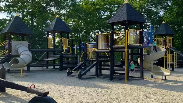
Branford, CT has a few great parks where kids can get their energy out or get together with their friends. Hover over each point on the map to see where each park is located, and read what each park has to offer below. Bayview Park Bayview Park is located in the Stony Creek-Thimble Island Historic District at the corner of Thimble Island Rd and Sachem Rd. Just past the park is the Stony Creek Beach and Thimble Island Ferry dock. Bayview Park had a playground, a basketball court, and covered picnic area. Playground Basketball Court Covered Picnic Area Parking: Street Location: Corner of Thimble Island Rd & Sachem Rd, Branford, CT Branford Hills Park & Field Branford Hills Park and Field is located where the Branford Hills School used to sit. The school was demolished in 2016 and a playground and recreational area built in its place. The park has two large field, swings, basketball court, and a playscape area. Playground Basketball Court Soccer FIeld Baseball Field Parking: Parking Lot, Off Street Location: Corner of Burban Rd and Jefferson Rd, Branford, CT Parker Memorial Park at Branford Point Beach Parker Memorial Park is located at the entrance to Branford Point and Branford Point Beach. It has a playscape with slides and a swing area. The nice feature of the park and beach is the building with full bathrooms, open during summer season. Off season, a port-a-potty is available near the parking lot. Playground Beach Picnic Areas Parking: Large Parking Lot (requires Branford Town sticker between Labor Day and Memorial Day), Small Parking Lot at the Point Location: 20 Harbor St, Branford, CT Branford Point Beach at Branford Point Branford Point is a popular spot throughout the year, drawing beach goers during the summer and nature lovers all year round. With trees and picnic tables throughout, it offers plenty of shaded spots to sit and relax. The dock at Branford Point is a popular fishing spot. The beach has outdoor showers for rinsing off, and a building with full bathrooms is available during summer season. Off season, a port-a-potty is available near the parking lot. Playground (see Parker Memorial Park above) Beach Picnic Areas Fishing Dock Parking: Large Parking Lot (requires Branford Town sticker between Labor Day and Memorial Day), small parking lot at the Point Location: 20 Harbor St, Branford, CT Foote Memorial Park Foote Memorial Park is one of the larger parks in Branford, CT. It contains walking trails, covered picnic areas, tennis courts, a baseball field, basketball court, large open green area, and two plagrounds, one for older kids and one for little ones. The main parking lot required a Branford Town sticker between Labor Day and Memorial Day, however there is a small parking available to everyone at the entrance to the park. Two Playground areas (one for kids up to 5, and one for kids 5+) Basketball Court Tennis Courts Baseball Field Walking Trails Picnic Areas Parking: Two Parking Lots (large lot requires Branford Point Sticker between Labor Day and Memorial Day). Location: 12 Melrose Ave, Branford, CT Hammer Field and Joseph Trapasso Community House Hammer Field and the Joseph Trapasso Community House are located near Branford Center, adjacent to Sliney Elementary School. The Community House offers a lot of activities throughout the year, including before and after-school care for kids. Visit the Community House website for most current activities and registration information. Playground Basketball Court Baseball Field Multifunction Field Picnic Areas Parking: Parking Lot, Street Parking Location: 46 Church St, Branford, CT Pardee Park Pardee Park is located in the Short Beach community and has a playscape, basketball court, and a large open field. Playground Basketball Court Multifunction Field Parking: Small Parking Lot Location: Westwood Rd, Branford, CT Patty's Park Patty’s park is a playground located behind the Mary T. Murphy Elementary School. It includes a small rock climbing wall, various games (ex: food tic-tac-toe, dinosaur “fossils”), a basketball court, and a swing area. The entrance to the parking lot is on Parish Farm Rd. There is a soccer field to the right of the park, and a big kid playscape is located in the front of the Murphy School. Playground Basketball Court Multifunction Field Parking: Parking Lot Location: Parish Farm Rd, Branford, CT Veteran's Memorial Park Veteran’s Memorial Park is located about half a mile north of I-95, on Brushy Plain Rd and has quite a bit to offer. It has a playground area, basketball court, two baseball fields, several soccer fields, and a tennis courts. Playground Baseball Fields (2) Basketball Court Soccer Fields Tennis Courts Parking: Parking Lot Location: 120 Brushy Plain Rd, Branford, CT Veteran's Memorial Park in Branford, CT Do you have other places around town your kids like exploring? Let us know your favorite spots around Branford, CT to take your kids to!

Featured Town: Guilford
Quick Facts about Guilford LOCATION New Haven County, located along I-95 and the Connecticut coast AREA & GEOGRAPHY49.7 sq mi. Guilford’s landscape includes rolling farmlands, numerous historic homes and sites, a Historic Town Green, and a shoreline bordering Long Island Sound. POPULATIONAppx. 22.1K (as of 2020 census) COMMUTER INFORMATION (average car trip times)Hartford: 55minNYC: 1hr 45minBoston: 2hrs 20min Communities GUILFORD CENTER (TOWN GREEN) The Guilford Town Green is a rectangular area measuring about 12 acres. It is is bordered by Park Street, Broad Street, Whitfield Street, and Boston Street and has the third largest collection of historical homes in New England, from the 17th, 18th and 19th centuries The green has paths running across the park as well as radiating out in two star patterns, creating a unique landscape. The Town Green is surrounded by city offices, restaurants, and shops and is often utilized for annual fairs. LEETES ISLAND Leetes Island is Guilford’s shoreline community and features a tidal marsh, a 40-acre tidal wetland that has been privately owned by the same family, Leetes family, since colonial times. A man-made channel connects the march to Island Bay and Long Island Sound. NORTH GUILFORD North Guilford is a largely wooded area with several hiking and horse trails bringing you close to nature. Many homes in North Guilford have larger lots, offering more privacy and seclusion. NUT PLAINS The Nut Plains area of Guilford is located north of I-95 and includes the Nut Plains Woods Land Trust. Nut Plains Woods feature nature trails, include a trail around the perimeter of the property that takes you back to the starting point. SACHEMS HEAD The Sachems Head community is the southernmost part of Guilford. The shorelines includes the Sachems Head Yacht Club and Sachem Head Harbor. Architectural Highlights Many charming, historical homes from the 17th, 18th, and 19th centuries. Resources Use the resources below to explore the town’s amenities and services. Town Hall Website Guilford Schools Library Parks & Recreation Department UTILITIESConnecticut Water Eversource – Electric Service Hocongas – Propane and Heating Oil Delivery Guilford Police Department (a great resource to ask about local safety statistics) Guilford Fire Department Town information source: Wikipedia (Creative Commons License)
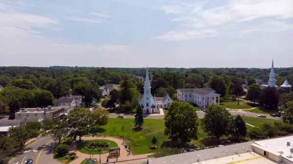
Featured Town: Branford
Quick Facts about Branford LOCATION New Haven County, East of Quinnipiac River, about 6 miles east of downtown New Haven AREA & GEOGRAPHY28 sq mi. The Branford shoreline borders Long Island Sound and features several town and private beach areas. Over 20% of Branford is water, including the Branford River, Queach Brook and the Branford Supply Ponds. Branford also includes the Thimble Islands. POPULATIONAppx. 27.9K (as of 2020 census) COMMUTER INFORMATION (average car trip times)Hartford: 50minNYC: 1hr 40minBoston: 2hrs 25min Historic Communities Branford’s community includes six historic districts that are listed on the US National Register of Historic Places and feature buildings in the Federal, Arts and Crafts, and Queen Anne style architecture. BRANFORD CENTER Branford Center is home to many small stores, restaurants, and coffee houses, which line Main Street, with the Green at the center. The Branford Green has churches as well as the town hall and other government facilities and hosts concerts and other events, such as the annual Branford Festival. Traditionally, the graduating class from Branford High School graduates in front of the Town Hall, weather permitting. BRANFORD POINT HISTORIC DISTRICT The Branford Point district was listed on the National Register of Historic Places in 1988. It includes a significant portion of the Branford Point neighborhood, generally considered to be the area along the west side of the Branford Harbor to the Amtrak railroad tracks. This area is historically notable for housing Branford’s highest concentration of late 19th and early 20th century residential architecture. Up to the mid-19th century, this area was mainly farmland and difficult to reach from Branford Center. Harbor Street, with its bridge over Mill Brook, and Maple Avenue were both laid out in 1819, providing improved access. Beginning in the mid-19th century George Parker developed the area around Branford Point as a day resort, with a beach and wharf. His heirs eventually donated the property to the town to form Parker Memorial Park. The northern portion of the district developed as a residential area for workers at the nearby iron foundry (located just north of the district). The result of this development pattern was an assemblage of residences including late 18th-century farmhouses, Greek Revival houses of the mid-19th century, late 19th-century Victorians, and Colonial Revival houses of the early 20th century. CANOE BROOK HISTORIC DISTRICT small but ethnically diverse residential area west of the center of Branford, Connecticut, which exhibits more than 200 years of architectural history. It extends from Cherry Hill Road in the north to Bradley Street in the south, including portions of Main Street, Home Place, and North Harbor Street. It was listed on the National Register of Historic Places in 2002. The district takes its name from Canoe Brook, a waterway now largely built over by North Main Street and other construction. The district is about 52 acres in size, with 51 historic residences. There are a few commercial and civic structures in the district, including two schools and a fire station, as well as a modest number of non-historic buildings. Most of the residences are wood frame structures, and are in a diversity of styles, from the early colonial Harrison houses to early 20th century Tudor Revival houses on Cherry Hill Road. ROUTE 146 HISTORIC DISTRICT The Route 146 district encompasses a historic streetscape in Branford and Guilford, Connecticut. Extending along Connecticut Route 146 between Flat Rock Road in Branford and the West River bridge in Guilford, it includes two centuries of rural residential architecture, and a well-preserved pre-World War II street layout created as a “state assistance road” in the 1920s. The district was listed on the National Register of Historic Places in 1990. The district is about 169 acres (68 ha) in size, and includes the entire road right-of-way for Route 146 between the West River in Guilford and Flat Rock Road in Branford. It abuts the Guilford Historic Town Center to the east and the Stony Creek–Thimble Islands Historic District to the west. The built architecture of the district is entirely residential, representing a cross-section of rural styles covering 200 years from the early 18th to early 20th centuries. STONY CREEK & THIMBLE ISLANDS HISTORIC DISTRICT is a historic district encompassing a 19th-century summer resort area in Branford, Connecticut. Located in the southeastern part of the town, it encompasses the mainland Stony Creek neighborhood, and all of the major Thimble Islands which lie offshore from Stony Creek in Long Island Sound. The district includes a well-preserved array of domestic summer resort architecture spanning more than a century preceding World War II, as well as worker housing and other artifacts related to the area’s brief importance as a granite quarry. The district was listed on the National Register of Historic Places in 1988. Stony Creek is a shore front neighborhood in the southeastern section of Branford, centered on a harbor on Long Island Sound. An eclectic community, Stony Creek has the ambiance of a small seaside village with a blend of various architectural style buildings and a few small retail establishments, sandwich shops, galleries and shop. Just offshore from Stony Creek is an intriguing archipelago of islands known as the Thimble Islands. The Thimbles are a jumble of glacial rocks, ranging from 17 acres (6.9 ha) down to stepping-stone size, at the mouth of the harbor. Despite their small size, they possess a wealth of history and local lore, as well as providing pleasant scenery for a summer cruise. The 1,400-acre (5.7 km2) area of the district includes much of the Stony Creek mainland area of Branford, along Thimble Islands Rd. between Rt. 146 and Long Island Sound, and includes all of the major Thimble Islands. Only a few buildings predate the resort period, including examples of Georgian and Federal architecture. There is one notable example of Greek Revival architecture from the 1840s: it is a cottage on Money Island. Italianate houses from the 1850s tend to be modest in scale and style, and are mainly located in the Stony Creek village area, which served the local granite quarries. Later Victorian-style houses are located throughout the area, which is known for its particularly large and well-preserved collection of Stick style houses. Probably the most elaborate of these is the William J. Clark House at 32 Prospect Hill, which is separately listed on the National Register. It was designed by the New Haven architect Henry Austin. BRANFORD HILLS Branford Hills sits on the western end of town and centers on the heavily commercialized strip of U.S. Route 1. Fast-food and sit-down restaurants, auto dealers, grocery stores, and several strip malls are located there. The more southern section features less dense areas with woodlands and farm featuring trails that the Branford Land Trust preserves that connect the Shoreline Greenway trail from New Haven to Madison. The northern section also features a less dense area with woodlands that surround Lake Saltonstall which also feature trail systems maintained by the Regional Water Authority, as the Lake is a reservoir for Branford. Branford Hills features many condominium and apartment complexes. INDIAN NECK Indian Neck is in the south-central section of Branford, dominated by a peninsula bordering Branford Harbor. Both Foote Park and John B. Sliney Memorial Park are located within Indian Neck. PINE ORCHARD Pine Orchard is situated between Indian Neck and Stony Creek. The Pine Orchard Yacht and Country Club, the Pine Brook School, a private institution, and Francis Walsh Intermediate School are found here. SHORT BEACH Short Beach is a beach neighborhood in the western end of town, south of Branford Hills. It is home to many small private islands, the largest being Kelsey Island, which has a handful of small cabins used as summer homes. There is no public access (except for public tidal zones) to Kelsey Island and trespassing is not allowed. Short Beach is home to half of the famous Shore Line Trolley Museum, which is also in neighboring East Haven. HOTCHKISS GROVE Hotchkiss Grove of Branford is located between Indian Neck and Pine Orchard and consists of First through Ninth avenues, as well as parts of Hotchkiss Grove Road, Seaview Avenue, and Dudley Avenue. It has a small beach used for swimming and mooring boats and features a raft to swim out to. Bay Point Park (The Point) is a grassy peninsula going out into the water where there used to be a small pier. Architectural Highlights Historic buildings featuring Federal, Arts and Crafts, and Queen Anne style architecture Resources Use the resources below to explore the town amenities, services. Town Hall Website Branford Schools Library Parks & Recreation Department UTILITIESRegional Water Authority United Illuminating – electric Southern Connecticut Gas Company Branford Police Department (a great resource to ask about local safety statistics) Branford Fire Department Town information source: Wikipedia (Creative Commons License)
Categories
Recent Posts
